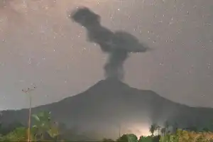
Mount Semeru, located on the border of Lumajang and Malang regencies, East Java, recorded a significant increase in volcanic activity on Tuesday (30/6/2026). Over a 12-hour period, the highest mountain on Java Island was recorded to have erupted five times, with ash column heights varying between 500 and 900 meters above the peak.
Sigit Rian Alfian, an officer at the Mount Semeru Observation Post, reported that the latest eruption occurred at 13:04 WIB, with an ash column observed 900 meters high, reaching 4,576 meters above sea level. The volcanic material was observed to be white to gray with thick intensity, moving to the northeast and east. Based on seismograph recordings, this eruption had a maximum amplitude of 21 mm with a duration of 99 seconds.
Currently, the status of Mount Semeru remains at Level III (Alert). The public is advised to comply with the exclusion zones established by the Center for Volcanology and Geological Hazard Mitigation (PVMBG). The designated safe radius includes a distance of five kilometers from the crater or peak, given the danger of glowing rock ejecta that could endanger public safety.
In addition, authorities emphasized a prohibition on activities in the southeastern sector along Besuk Kobokan within a 13-kilometer radius from the eruption center. The public is also forbidden from approaching within a 500-meter radius from the riverbanks along that flow, considering the potential threat of pyroclastic flows and lahar flows that could extend up to 17 kilometers from the mountain peak.
Residents active around valleys or river basins originating from Semeru's peak, such as Besuk Bang, Besuk Kembar, and Besuk Sat, are urged to exercise extra vigilance against potential lava avalanches and cold lahar floods that could occur at any time.