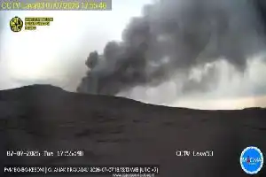
Mount Semeru, located in East Java, displayed significant volcanic activity again on Thursday (9/7/2026). The eruption was recorded at 01:08 WIB, spewing a column of ash approximately 700 meters above the peak, or reaching 4,376 meters above sea level.
According to a report from the Center for Volcanology and Geological Hazard Mitigation (PVMBG) via the MAGMA Indonesia application, the observed ash column was thick and drifting towards the north and northwest. Seismograph records showed the eruption had a maximum amplitude of 22 millimeters with a duration of 121 seconds.
As of now, Mount Semeru's status remains at Level III (Alert). Seismic monitoring data for the period of July 9 from 18:00 to 23:59 WIB recorded 11 eruption earthquakes, two rockfall earthquakes, and four emission earthquakes, indicating that the mountain's condition remains highly dynamic.
Relevant authorities have issued a strict warning to the public and hikers to avoid any activity in the southeastern sector along Besuk Kobokan, within a 13-kilometer radius from the eruption center. Additionally, residents are advised to maintain a safe distance of at least 500 meters from the riverbanks along the flow path to anticipate potential hot clouds and lahar flows.
MAGMA Indonesia records show that throughout 2026, Mount Semeru has been the most active volcano in Indonesia, with a total of 1,355 eruptions. This figure contributes significantly to the total of 3,040 volcanic eruptions recorded across Indonesia during the same period.