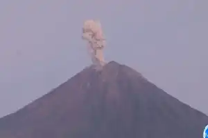
Mount Semeru, located on the border of Lumajang and Malang regencies, once again showed an increase in volcanic activity on Monday (29/6/2026). Mount Semeru Observation Post officers reported an eruption at 16:39 WIB with the eruption column reaching a height of 1.2 kilometers above the peak.
Based on seismograph data, the eruption was recorded with a maximum amplitude of 22 mm and a duration of 2 minutes and 9 seconds. The resulting ash column was observed to be white to gray with thick intensity, moving toward the northeast and east sectors.
Throughout Monday, vulcanological authorities recorded nine eruptions from 00:04 to 19:23 WIB. This activity keeps Mount Semeru at Status Level III or Alert. Despite moderate rumbles, the Lumajang Regional Disaster Management Agency (BPBD) confirmed that to date there have been no reports of direct adverse impacts on communities around the mountain slopes.
The Chief Executive of BPBD Lumajang, Isnugroho, emphasized that his team continues to conduct intensive monitoring at several standby posts, including in Curahkobokan and Oro-oro Ombo. The public is urged to comply with the activity exclusion zone, particularly along Besuk Kobokan up to a distance of 13 kilometers from the eruption center.
In addition, residents are also prohibited from conducting activities within a five-kilometer radius of the crater to avoid the danger of incandescent rock ejecta. The BPBD also stressed the importance of alertness against the threats of pyroclastic flows, lava avalanches, and cold lahar flows along the rivers originating from Mount Semeru, such as Besuk Bang, Besuk Kembar, and Besuk Sat.