The Bromo Tengger Semeru National Park Management Center (TNBTS) has tightened hiking access on Mount Semeru following a significant, ongoing increase in volcanic activity. Tourists and hikers are now only permitted to conduct activities up to the Ranu Kumbolo area, while access toward Kalimati and the summit of the highest mountain on Java Island remains completely closed.
Public Relations Officer of the TNBTS Management Center, Endrip Wahyutama, emphasized that this restriction policy is a crucial risk mitigation step. Given that Mount Semeru's status is currently at Level III (Alert), the relevant authorities are offering zero tolerance for anyone seeking to cross safe boundaries, in order to guarantee the safety of visitors' lives.
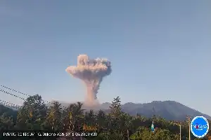
Previously, Mount Semeru was reported to have erupted on Friday (6/19/2026) at 07:21 WIB. Data from the Center for Volcanology and Geological Hazard Mitigation (PVMBG) recorded an eruption column height of 1,000 meters above the peak, with thick gray ash dispersing toward the north and northwest.
In addition to ash spews, observation post officers recorded pyroclastic density currents (hot clouds) traveling as far as 4.5 kilometers toward Besuk Kobokan. This phenomenon was recorded with an eruption duration of over five minutes, confirming that the geographical conditions around Semeru's slopes are still unsafe for hiking activities.
TNBTS authorities continue to urge the public and tourists to strictly observe official recommendations from the PVMBG. Discipline in adhering to prohibited zones is expected to minimize potential hazards that could threaten safety in the national park area at any time.