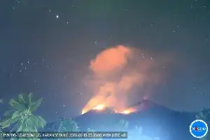
Volcanic activity of Mount Semeru on the border of Lumajang and Malang regencies, East Java, still shows high intensity. Throughout 2026 until mid-July, the tallest volcano on Java Island has recorded 1,486 eruptions, with its activity status maintained at Level III or Alert.
The latest report from the Mount Semeru Observation Post recorded seven consecutive eruptions within a six-hour period from early Thursday (16/7/2026) to morning. The observed eruptions spewed volcanic ash columns 700 to 1,100 meters above the crater peak, or about 4,776 meters above sea level.
Mount Semeru Observation Post officer, Liswanto, explained that seismic activity was dominated by eruption and avalanche earthquakes. During the observation period on Thursday from 00:00 to 06:00 WIB, 15 eruption earthquakes with amplitudes of 13-22 millimeters were recorded. The previous day, activity was even more intense with 66 eruption earthquakes and one occurrence of pyroclastic density current.
Responding to these unabated conditions, the Center for Volcanology and Geological Hazard Mitigation (PVMBG) urges the public to comply with danger zone recommendations. Residents are prohibited from conducting activities in the southeastern sector along Besuk Kobokan up to a radius of 13 kilometers from the summit, as well as an area 500 meters from the riverbanks to anticipate the expansion of pyroclastic flows and lahar floods which could potentially flow up to 17 kilometers away.
Additionally, a sterile radius of five kilometers from the active crater is also enforced to avoid the threat of flying incandescent rocks. Similar warnings also apply along the tributaries such as Besuk Bang, Besuk Kembar, and Besuk Sat, which originate directly at the summit of Semeru, considering that the accumulation of volcanic material in the crater remains highly dynamic and could collapse at any time.