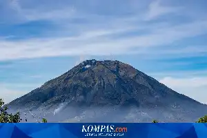
Mount Semeru is currently at Level III (Alert) status after experiencing a series of eruptions since the end of last June. However, geologists warn that the threat to communities around the mountain slopes comes not only from direct volcanic material discharge, but also from the latent danger of lahar floods that can occur at any time.
Dr. Indranova Suhendro, a geography expert from Gadjah Mada University, emphasized that the accumulation of eruptive materials, such as sand and rocks on the mountain slopes, is highly vulnerable to being washed away by rainwater. Lahar floods pose a significant threat because they can occur without early warning, especially if heavy rain pours over the summit area while the residential areas below remain clear.
This phenomenon places river channels originating from Mount Semeru, particularly the Besuksemut River, as high-danger zones. Volcanic materials carried by the current can include large boulders with the potential to strike anything along the river flow path. Therefore, the Center for Volcanology and Geological Hazard Mitigation (PVMBG) continues to urge residents to stay away from the danger radius and refrain from activities near the river channels.
Unfortunately, these warnings are often ignored by traditional sand miners who still depend on the lahar flow paths for their livelihood. Dr. Nova acknowledged that this issue is highly complex, as it clashes the aspects of disaster mitigation with the economic realities of the local community.
Although mining activities at the site are scientifically strictly prohibited for safety reasons, he assesses the need for a more comprehensive policy. The main challenge now is how the government can balance protecting residents' lives from hard-to-predict disaster threats with sustaining the local community's livelihoods.