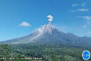
Mount Ibu, located in North Maluku, showed renewed volcanic activity on Monday (13/7/2026) afternoon. According to a report by the Center for Volcanology and Geological Hazard Mitigation (PVMBG) via the MAGMA Indonesia application, the eruption was recorded at 17:15 WIT.
The eruption produced a gray ash column of thick intensity, observed reaching a height of 400 meters above the peak, or approximately 1,725 meters above sea level. The volcanic ash drift was reported to be moving towards the north. Seismograph recordings showed the eruption had a maximum amplitude of 28 millimeters with an activity duration of 54 seconds.
To date, the status of Mount Ibu remains at Level II (Alert). Seismic records throughout Monday indicated a fairly high intensity of activity, with 83 eruption earthquakes, 13 harmonic earthquakes, and 82 low frequency earthquakes recorded.
Responding to these conditions, authorities reiterated the ban on activities for both the public and tourists within a 2-kilometer radius of the active crater. In addition, there is a sectoral expansion of 3.5 kilometers specifically for the crater opening area in the northern part to anticipate the danger of ejected volcanic material.
Throughout 2026, the intensity of volcanic eruptions in Indonesia has been quite active. Data shows that 3,153 volcanic eruptions have occurred across the country. Mount Semeru still holds the top position with 1,393 eruptions, while Mount Ibu follows with 1,042 eruptions during the same period.