The Geological Agency of the Ministry of Energy and Mineral Resources (ESDM) firmly denied the authenticity of a video widely circulating on social media, which is claimed to show the eruption of Mount Anak Krakatau. Based on an in-depth verification, the visual footage was confirmed not to be genuine activity from the volcano located in the Sunda Strait.
Acting Head of the Geological Agency, Lana Saria, emphasized the importance of the public being critical of unverified information. She urged the public not to share content that could potentially cause public unrest and advised always referring to official communication channels belonging to the Geological Agency, the Centre for Volcanology and Geological Hazard Mitigation (PVMBG), and the MAGMA Indonesia application for the latest data.
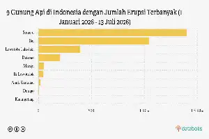
Despite the circulating hoax, the Geological Agency acknowledged that Mount Anak Krakatau is indeed showing low-energy magmatic activity. Two eruptions were recorded on July 2 and 3, 2026, with ash columns reaching a height of 200 meters above the peak. All of this activity data has been accurately recorded via seismographs and published transparently.
Furthermore, the volcanological authority corrected the misleading narrative regarding the danger zone radius. Currently, the public, tourists, and fishermen are prohibited from approaching within a 3-kilometer radius of the eruption center, not 5 kilometers as rumored among the public.
Regarding concerns among coastal residents of Banten and Lampung about potential tsunamis, the Geological Agency asked the public to remain calm and not be influenced by groundless rumors. Residents are expected to continue their daily activities as usual while monitoring official directions from local governments and local Disaster Management Agencies (BPBD).