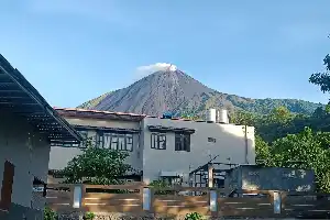
Mount Semeru, located in Lumajang, East Java, has once again shown a significant increase in volcanic activity. On Tuesday (14/7/2026) morning, the highest mountain on the island of Java was recorded experiencing a series of continuous eruptions, with the eruption column reaching 1.3 kilometers above the Mahameru peak, or about 4,976 meters above sea level.
The Mount Semeru Observation Post in Sumberwuluh Village reported that the 1.3-kilometer-high eruption was observed twice, specifically at 05:39 WIB and 09:19 WIB. The first eruption spewed a white to gray ash column of moderate intensity moving towards the north. Meanwhile, in the second eruption, a thick ash column moved towards the northeast and east.
Mount Semeru Observation Post officer, Sigit Rian Alfian, explained that this volcanic activity was recorded on the seismograph with a maximum amplitude of 23 mm and a gust earthquake duration of about 116 seconds. Cumulatively, Mount Semeru has experienced at least seven eruptions from midnight until just before noon, specifically from 00:32 WIB to 11:13 WIB, with the eruption column height ranging from 800 meters to 1.3 kilometers.
Currently, the activity level of Mount Semeru remains at Level III (Alert) status. In connection with these conditions, the authorities urge the public to comply with the danger zone and not to conduct any activities in the southeastern sector along the Besuk Kobokan flow up to a distance of 13 kilometers from the eruption center.
Beyond that radius, residents are also prohibited from conducting activities within 500 meters of the banks of the Besuk Kobokan River due to the potential overflow of hot pyroclastic clouds and lahar flows that could reach up to 17 kilometers from the peak. In addition, a sterile radius of 5 kilometers from the active crater remains in effect to avoid the danger of ejecting incandescent rocks. The public is also asked to be alert to river flows originating from Semeru, including Besuk Bang, Besuk Kembar, and Besuk Sat.